
Geospatial Analytics AI Market Report 2026
Global Outlook – By Data Source (Navigation Satellite System (GNSS), Remote Sensing, Geo Tagging, Other Data Sources), By Solution (Hardware, Software, Services), By Deployment (Cloud, On-Premises), By Application (Real Estate, Sales And Marketing, Coastal Application, Agriculture, Fraud Detection, Surveying, Hazard Assessment, Natural Resource Management, Transportation And Logistics, National Labs, Other Applications) – Market Size, Trends, Strategies, and Forecast to 2030
Geospatial Analytics AI Market Overview
• Geospatial Analytics AI market size has reached to $0.14 billion in 2025 • Expected to grow to $0.54 billion in 2030 at a compound annual growth rate (CAGR) of 30.8% • Growth Driver: Internet Usage Penetration's Effect On Geospatial Analytics AI Market • Market Trend: Integration Of AI And Geospatial Platforms For Enhanced Scenario Planning And Monitoring • Asia-Pacific was the largest region in 2025.Market Gains By 2030 – Top Opportunities By Segment
Market Gain identifies the most promising market opportunities by highlighting the segments or products expected to generate the highest incremental revenue growth over the next five years.
What Is Covered Under Geospatial Analytics AI Market?
Geospatial analytics artificial intelligence (AI) refers to the integration of artificial intelligence (AI) techniques and algorithms to analyze and derive insights from geospatial data. Geospatial Analytics AI systems process vast amounts of geographical data to extract meaningful patterns, trends, and correlations and enable organizations to make data-driven decisions and solve complex spatial problems across various domains. The main types of geospatial analytics AI are navigation satellite systems (GNSS), remote sensing, geo tagging, and others. A navigation satellite system (GNSS) is a network of satellites that provide positioning, navigation, and timing data to users on or near the Earth's surface. Various types of solutions are included, such as hardware, software, and services, and can be deployed on the cloud and on-premises. It is used for many applications, including real estate, sales and marketing, coastal applications, agriculture, fraud detection, surveying hazard assessment, natural resource management, transportation and logistics, national labs, and others.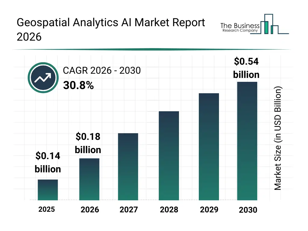
What Is The Geospatial Analytics AI Market Size and Share 2026?
The geospatial analytics AI market size has grown exponentially in recent years. It will grow from $0.14 billion in 2025 to $0.18 billion in 2026 at a compound annual growth rate (CAGR) of 30.7%. The growth in the historic period can be attributed to adoption of gps and gnss systems, use of satellite-based remote sensing, integration with surveying and hazard assessment, early adoption in agriculture and natural resource management, deployment in real estate and marketing analytics.What Is The Geospatial Analytics AI Market Growth Forecast?
The geospatial analytics AI market size is expected to see exponential growth in the next few years. It will grow to $0.54 billion in 2030 at a compound annual growth rate (CAGR) of 30.8%. The growth in the forecast period can be attributed to increased use of lidar and hyperspectral imaging, adoption of cloud-based geospatial analytics platforms, growth in coastal and environmental monitoring, expansion in transportation and logistics applications, integration with crowd-sourced and drone geospatial data. Major trends in the forecast period include ai-powered geospatial data analytics, predictive spatial modeling, real-time geospatial insights, geo-tagged social media analysis, remote sensing integration.
Global Geospatial Analytics AI Market Segmentation
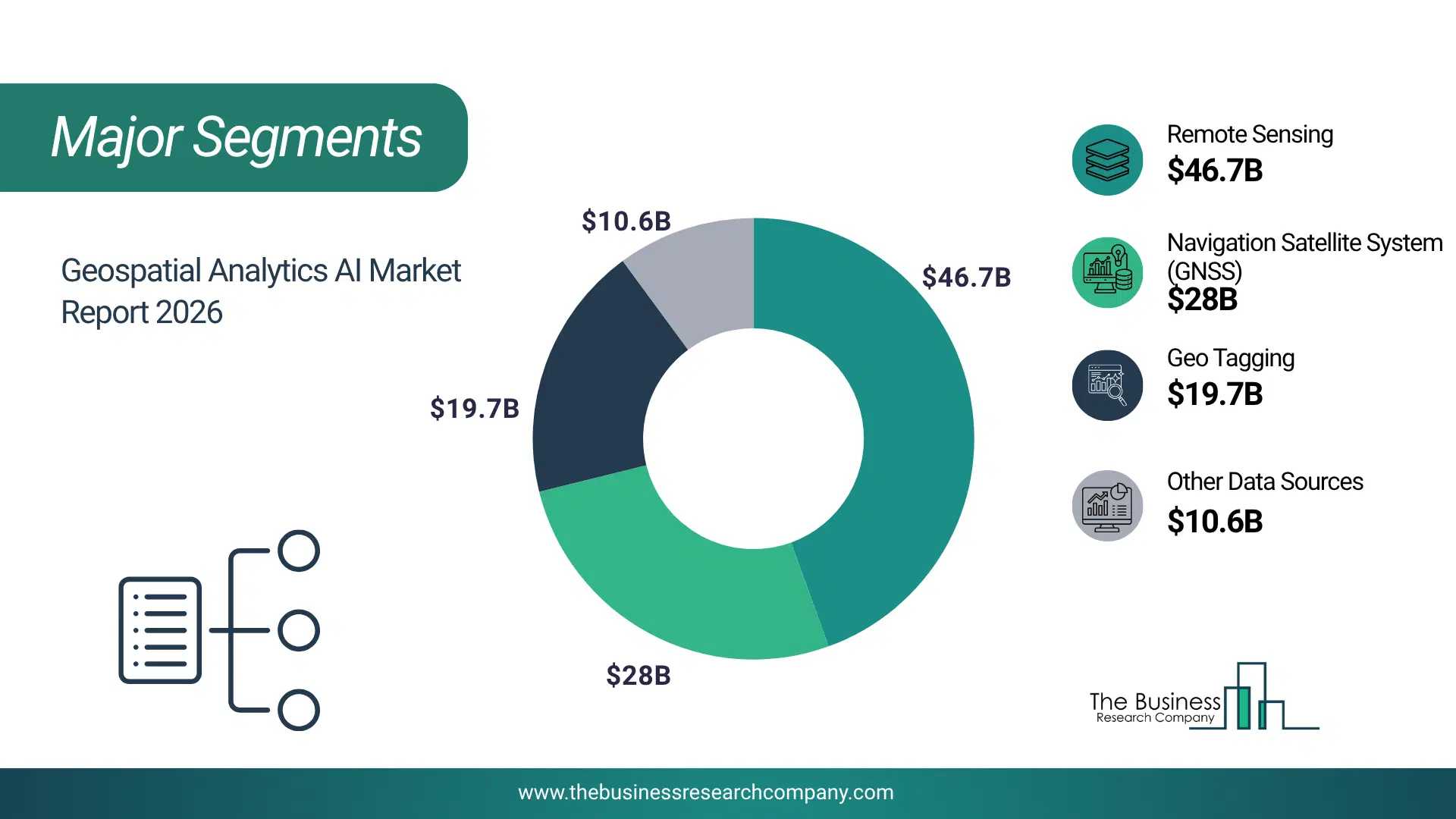
1) By Data Source: Navigation Satellite System (GNSS), Remote Sensing, Geo Tagging, Other Data Sources 2) By Solution: Hardware, Software, Services 3) By Deployment: Cloud, On-Premises 4) By Application: Real Estate, Sales And Marketing, Coastal Application, Agriculture, Fraud Detection, Surveying, Hazard Assessment, Natural Resource Management, Transportation And Logistics, National Labs, Other Applications Subsegments: 1) By Navigation Satellite System (GNSS): Global Positioning System (GPS), Glonass, Galileo, BeiDou, Other GNSS Systems 2) By Remote Sensing: Satellite-based Remote Sensing, Aerial-Based Remote Sensing, LiDAR (Light Detection And Ranging), Hyperspectral Imaging, Radar-Based Remote Sensing 3) By Geo Tagging: Social Media Geotagging, IoT Device Geotagging, Mobile Applications Geotagging 4) By Other Data Sources: Survey Data, Public Data Repositories, Crowd-Sourced Data, Geospatial Data From Drones The top segments in the geospatial analytics ai market will be: • Remote Sensing will reach $46.62 billion by 2030. • Navigation Satellite System (GNSS) will reach $27.94 billion by 2030. • Geo Tagging will reach $19.65 billion by 2030. • Other Data Sources will reach $10.59 billion by 2030.What Is The Driver Of The Geospatial Analytics AI Market?
The growth in internet penetration is expected to propel the growth of the geospatial analytics AI market going forward. Internet penetration refers to the percentage of a population or a specific demographic group that has access to the internet. Internet penetration occurs when a certain percentage of the population or a specific demographic group gains access to the internet, facilitating widespread connectivity, information access, communication, and economic opportunities. Internet penetration uses geospatial analytics AI to analyze and understand spatial patterns of internet usage, enabling targeted interventions and infrastructure development to increase connectivity in underserved areas and optimize resource allocation for enhanced digital inclusion. For instance, in October 2023, the International Telecommunication Union, a Switzerland-based specialized agency of the United Nations, about 67 percent of the global population, equating to 5.4 billion individuals, are now internet users, an increase from 5.1 billion in 2022. Therefore, growth in internet penetration is expected to propel the growth of the geospatial analytics AI industry.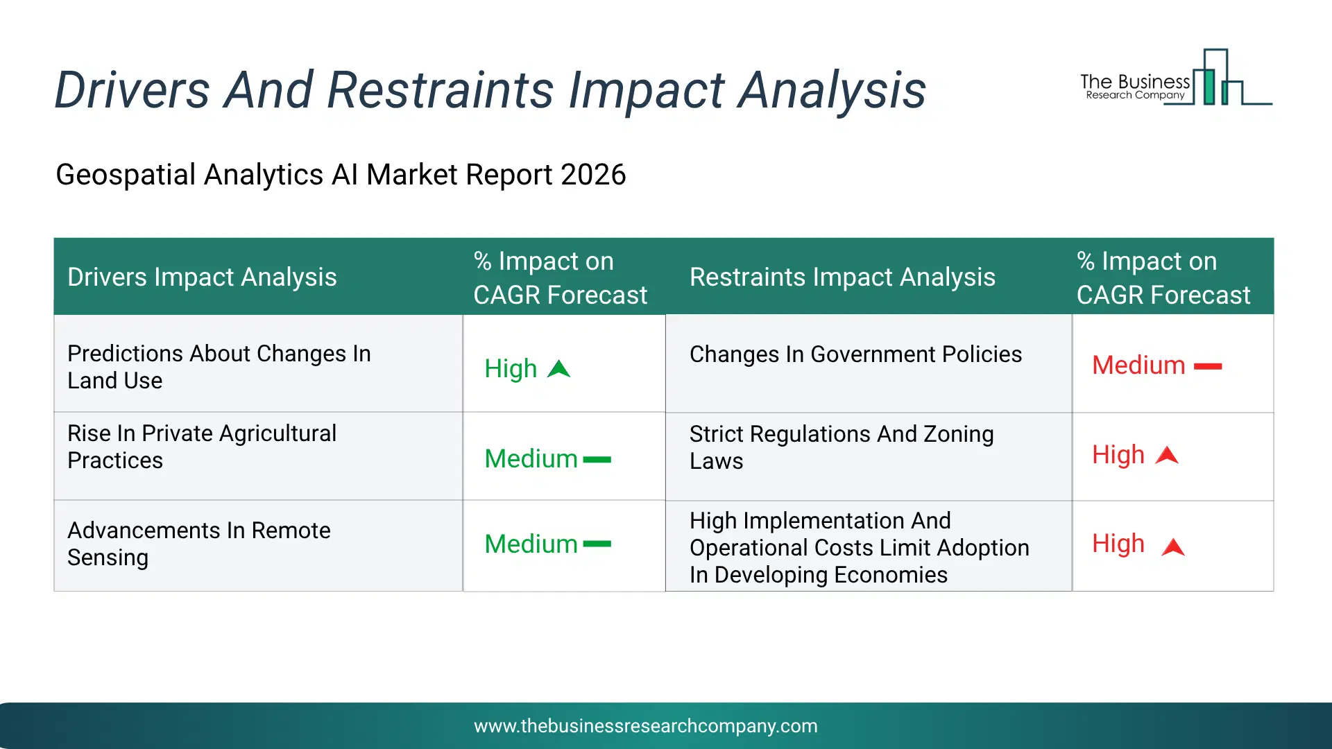
Infographic Chart Showing Key Market Drivers Analysis And Restraints For Geospatial Analytics Ai Market
The chart presents an impact analysis of key drivers and restraints, quantifying their relative influence on the market's growth rate and helping assess the balance between growth enablers and limiting factors. This chart offers a high-level perspective; the full report contains more detailed insights.
How Will The Drivers Impact Growth In The Global Geospatial Analytics AI Market?
• Predictions About Changes In Land Use (High) – During the forecast period, predictions about changes in land use are expected to emerge as a key growth driver for the geospatial analytics ai market by 2030. Governments, urban planners, and environmental agencies increasingly rely on geospatial ai to analyze spatial data and forecast trends such as urban expansion, deforestation, and infrastructure development. By integrating satellite imagery, gps data, and machine learning, these systems enable more accurate and sustainable planning decisions. The rising demand for real -time, data -driven land management solutions is accelerating investments in advanced geospatial technologies. • Rise In Private Agricultural Practices (Medium) – During the forecast period, the rise in private agricultural practices is expected to be a key driver of growth in the geospatial analytics ai market by 2030. Farmers and agribusinesses are increasingly adopting geospatial ai to enhance productivity, optimize resource use, and improve farm management. By leveraging data from drones, satellite imagery, and gps-enabled equipment, these technologies provide insights into soil health, crop conditions, irrigation, and weather patterns. This supports precision agriculture, enabling targeted use of inputs while reducing costs and environmental impact. • Advancements In Remote Sensing (Medium) – During the forecast period, advancements in remote sensing are expected to act as a key growth catalyst for the geospatial analytics ai market by 2030. Technologies such as satellites, drones, and lidar generate vast volumes of high-resolution spatial data, driving the need for advanced ai-based analysis. Ai enables efficient image recognition, object detection, and spatial pattern identification, enhancing decision-making across sectors like environmental monitoring, disaster management, and infrastructure planning. Improvements in sensor accuracy, imagery quality, and data transmission further strengthen real-time monitoring and predictive capabilities.How Will The Restraints Impact Growth In The Global Geospatial Analytics AI Market?
• Changes In Government Policies (Medium) – During the forecast period, the changes in government policies can significantly restrain the growth of the geospatial analytics artificial intelligence market because many geospatial technologies rely on regulatory approvals, national data policies, and government-supported infrastructure. Governments often control access to sensitive geographic data, satellite imagery, and location-based information due to security concerns. When policies change regarding data sharing, cross-border data transfer, or the use of aerial mapping technologies such as drones and remote sensing systems, organizations may face restrictions on collecting or processing geospatial data. These policy shifts can delay projects that depend on spatial data analytics for applications such as urban planning, environmental monitoring, or disaster management. In some cases, governments may impose limitations on high-resolution mapping or require special licenses for geospatial data usage, which increases compliance requirements for companies operating in this field. Frequent policy changes can also create uncertainty for businesses investing in geospatial ai technologies, making it difficult to plan long-term projects or expand operations. As a result, evolving regulatory frameworks and policy adjustments can slow market expansion and limit the adoption of geospatial analytics ai solutions. • Strict Regulations And Zoning Laws (High) – During the forecast period, the strict regulations and zoning laws can also act as a restraint on the geospatial analytics ai market because they affect how geospatial technologies and data collection systems are deployed. Many geospatial analytics solutions rely on devices such as drones, lidar scanners, and satellite imaging systems to capture accurate geographic data. However, these technologies are often subject to strict aviation rules, privacy laws, and land-use regulations. Governments may restrict drone operations in urban areas, near airports, or in sensitive zones such as military installations and protected environmental regions. Zoning regulations can also limit the installation of certain monitoring equipment or surveillance technologies required for real-time spatial data analysis. Additionally, organizations must comply with privacy laws when collecting geolocation data from individuals or communities, which can restrict large-scale spatial monitoring projects. These regulatory constraints increase administrative procedures, licensing requirements, and compliance costs for companies deploying geospatial ai solutions. As a result, strict regulatory frameworks and zoning restrictions can slow down project implementation and limit the scalability of geospatial analytics applications. • High Implementation And Operational Costs Limit Adoption In Developing Economies (High) – During the forecast period, the high implementation and operational costs represent another major restraint for the geospatial analytics artificial intelligence market, particularly in developing economies. Deploying geospatial ai solutions requires advanced hardware and software infrastructure, including gps receivers, lidar scanners, high-resolution cameras, unmanned aerial vehicles, and powerful data processing systems. Organizations must also invest in artificial intelligence platforms, cloud computing resources, and skilled professionals capable of managing complex geospatial datasets. The cost of acquiring and maintaining these technologies can be substantial, especially for governments and businesses operating in regions with limited financial resources. In addition, operational expenses such as system integration, software updates, data storage, and technical support add to the overall cost of implementation. Developing countries may prioritize basic infrastructure and essential services over advanced geospatial technologies, which slows market adoption. Limited funding, lack of technical expertise, and high equipment costs therefore restrict the widespread deployment of geospatial analytics ai solutions in emerging economies.Key Players In The Global Geospatial Analytics AI Market
Major companies operating in the geospatial analytics AI market are Alphabet Inc.; Microsoft Corporation; Amazon.com Inc.; Intel Corporation; IBM Corporation; Oracle Corporation; SAP SE; NVIDIA Corporation; Baidu Inc.; Hexagon AB; Trimble Inc.; DigitalGlobe Inc.; Environmental Systems Research Institute Inc. (Esri); Bentley Systems Inc.; Databricks Inc.; Dataiku Inc.; Climate X; Genesys International Corporation Ltd.; Geoblink SL; L3Harris Geospatial Solutions Inc.; Chloris Geospatial Inc.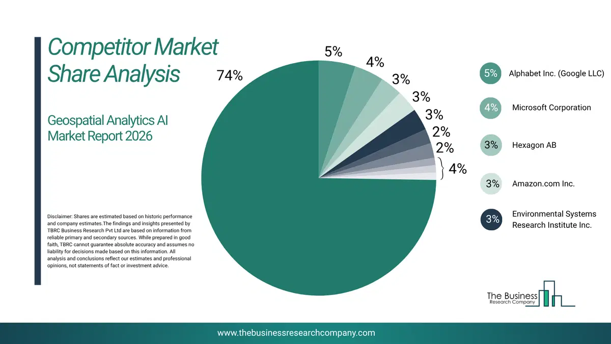
This chart is for illustrative purposes; the full report includes a detailed competitor analysis and comprehensive overview of the top 10 companies in the market.
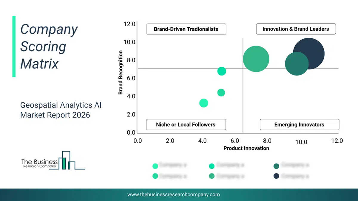
This chart maps companies by product innovation and brand strength, with bubble size indicating relative revenue, helping identify market leaders, challengers, and niche players. This is an illustrative chart; the full report provides a complete and accurate competitive analysis.
Global Geospatial Analytics AI Market Trends and Insights
Major companies operating in the geospatial analytics AI market are developing advanced technologies, such as geospatial and AI platforms, for scenario planning and monitoring and to gain a competitive edge in the market. The geospatial and AI platforms for scenario planning and monitoring are defined by the combination of geospatial technology and artificial intelligence (AI) to analyze and interpret data related to geographic locations. AI adds computational power and predictive abilities to this framework, enabling the extraction of valuable insights from vast amounts of geospatial data. For instance, in January 2024, Deloitte Touche Tohmatsu Limited, a UK-based professional services company, launched a geospatial and AI platform, powered by Google Cloud, that utilizes generative AI technology from Vertex AI. This platform helps clients improve their planning processes for disaster response, infrastructure development, and urban planning by providing insights on land use, which ultimately leads to more sustainable decision-making.What Are Latest Mergers And Acquisitions In The Geospatial Analytics AI Market?
In August 2025, Cyclomedia Technology Inc., a Netherlands-based technology company, acquired Detekt Bio medical L.L.C for an undisclosed amount. With this acquisition, Cyclomedia Technology Inc., moved to materially strengthen its Data Insights capabilities and AI-driven road-surface analytics to boost competitiveness in infrastructure and government tenders and to enhance its broader geospatial offering. Detekt Biomedical, L.L.C is an US-based technology company that specializes in an AI-powered platform that ingests mobile mapping data to automatically detect.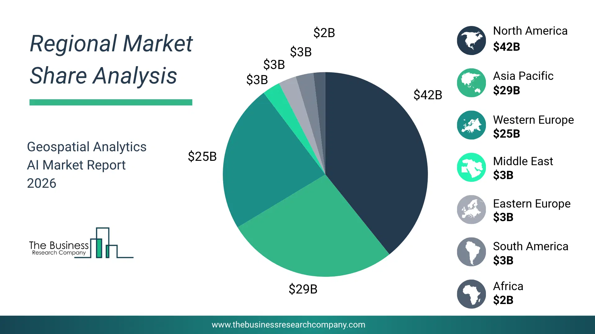
Regional Insights
Asia-Pacific was the largest region in the geospatial analytics AI market in 2025. The regions covered in this market report are Asia-Pacific, South East Asia, Western Europe, Eastern Europe, North America, South America, Middle East, Africa. The countries covered in this market report are Australia, Brazil, China, France, Germany, India, Indonesia, Japan, Taiwan, Russia, South Korea, UK, USA, Canada, Italy, SpainWhat Defines the Geospatial Analytics AI Market?
The geospatial analytics AI market includes revenues earned by entities by providing services such as spatial data processing, predictive modeling, real-time monitoring, and image recognition and analysis. The market value includes the value of related goods sold by the service provider or included within the service offering. The geospatial analytics AI market consists of sales of GPS (Global Positioning System) receivers, light detection and ranging (LiDAR) scanners, cameras, and unmanned aerial vehicles (UAVs). Values in this market are ‘factory gate’ values, that is the value of goods sold by the manufacturers or creators of the goods, whether to other entities (including downstream manufacturers, wholesalers, distributors and retailers) or directly to end customers. The value of goods in this market includes related services sold by the creators of the goods.How is Market Value Defined and Measured?
The market value is defined as the revenues that enterprises gain from the sale of goods and/or services within the specified market and geography through sales, grants, or donations in terms of the currency (in USD unless otherwise specified). The revenues for a specified geography are consumption values that are revenues generated by organizations in the specified geography within the market, irrespective of where they are produced. It does not include revenues from resales along the supply chain, either further along the supply chain or as part of other products.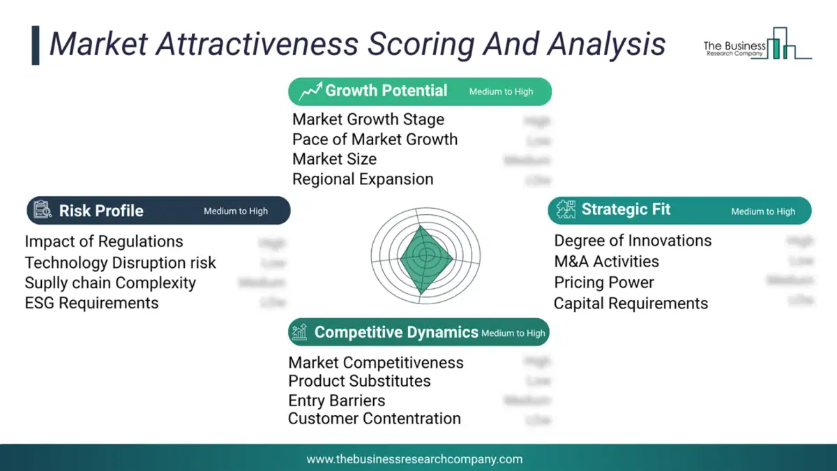
This chart presents market attractiveness based on a quantitative evaluation of growth, competition, strategic alignment, and risk, offering a clear view of opportunity areas for decision-making. This chart is for illustrative purposes; the full report contains the complete analysis.
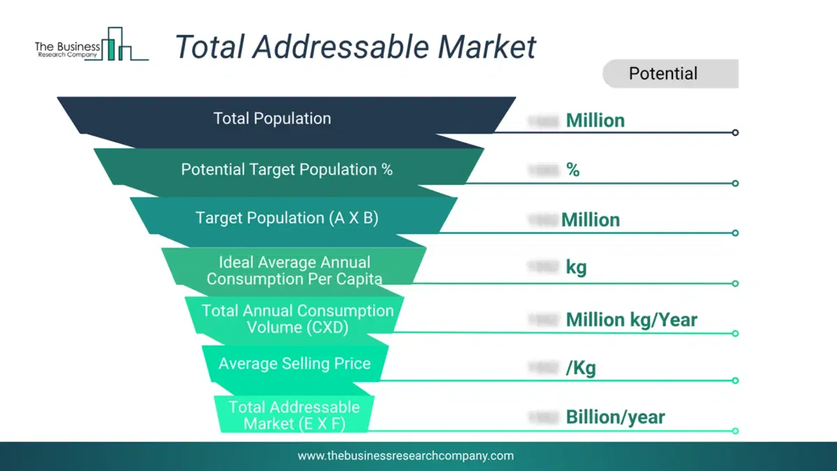
This chart highlights the Total Addressable Market (TAM) by estimating the maximum revenue opportunity using an assumption-driven approach, supporting strategic planning and opportunity sizing across markets. The chart is illustrative; the full report provides a more comprehensive analysis.
What Key Data and Analysis Are Included in the Geospatial Analytics AI Market Report 2026?
The geospatial analytics ai market research report is one of a series of new reports from The Business Research Company that provides market statistics, including industry global market size, regional shares, competitors with the market share, detailed market segments, market trends and opportunities, and any further data you may need to thrive in the geospatial analytics ai industry. The market research report delivers a complete perspective of everything you need, with an in-depth analysis of the current and future state of the industry.Geospatial Analytics AI Market Report Forecast Analysis
| Report Attribute | Details |
|---|---|
| Market Size Value In 2026 | $0.18 billion |
| Revenue Forecast In 2030 | $0.54 billion |
| Growth Rate | CAGR of 30.8% from 2026 to 2030 |
| Base Year For Estimation | 2025 |
| Actual Estimates/Historical Data | 2020-2025 |
| Forecast Period | 2026 - 2030 |
| Market Representation | Revenue in USD Billion and CAGR from 2026 to 2030 |
| Segments Covered | Data Source, Solution, Deployment, Application |
| Regional Scope | Asia-Pacific, Western Europe, Eastern Europe, North America, South America, Middle East, Africa |
| Country Scope | The countries covered in the report are Australia, Brazil, China, France, Germany, India, ... |
| Key Companies Profiled | Alphabet Inc.; Microsoft Corporation; Amazon.com Inc.; Intel Corporation; IBM Corporation; Oracle Corporation; SAP SE; NVIDIA Corporation; Baidu Inc.; Hexagon AB; Trimble Inc.; DigitalGlobe Inc.; Environmental Systems Research Institute Inc. (Esri); Bentley Systems Inc.; Databricks Inc.; Dataiku Inc.; Climate X; Genesys International Corporation Ltd.; Geoblink SL; L3Harris Geospatial Solutions Inc.; Chloris Geospatial Inc. |
| Customization Scope | Request for Customization |
| Pricing And Purchase Options | Explore Purchase Options |